Featured Products
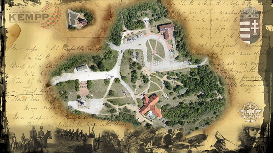
The Székesfehérvár organization of the Society for Military and Civil Cooperation and the Interspect Research Team has presented the world’s highest-resolution aerial ortho image mosaic.

The Hungarian Military Memorial Park became the subject of the world’s highest-resolution aerial ortho image mosaic
The previous record was held by the same team, who revealed a highly detailed ortho image mosaic of the Budapest Zoo back in 2009. World’s most detailed aerial ortho photo includes an aerial view of the Military Memorial Park, an important area of the National Memorial Place.
Becoming the world’s highest resolution aerial ortho image record holder
The Székesfehérvár organization of the Society for Military and Civil Cooperation and the Interspect Research Team in Hungary announced that their photo has a higher resolution than any other ortho photo ever taken from an aircraft or even a satellite. The organization claims that anybody who views the image will get the impression that the mosaic is part of a science-fiction movie.
Breakthrough technologies have been used in the making of the image, which is 400 times more detailed than the best image taken by a spy satellite and 300 times more detailed than any photo taken by an Earth-monitoring satellite. Moreover, the image has four times the resolution of the team’s previous record holder, an aerial image of the Budapest Zoo.
The National Memorial Place image is so detailed, Google Earth cannot display it
The team who took the photo says that Google Earth does not support it because its algorithm handles 23-zoom levels, while the image mosaic is made of 25-zoom levels. On top of that, Google Earth photos have a five times lower resolution.
The aerial image was taken from a Piper PA-32 Cherokee Six fast-moving aircraft and the team had to get the consent of the people working at the National Memorial Place. Their consent had to be obtained because the team leaders knew that the faces of the workers, students, and visitors would be identifiable in the final image.
Interspect Research Team’s members worked actively at this project for several years
The camera used at this project was developed by Gábor Bakó and Zsolt Molnár, who have been working at it since 2006. The pilot of the aircraft cruising through the air at speeds of 270 kilometers per hour was András Arady, while the geodesic field measurements were made in collaboration with Eszter Góber.
It was specified that the image could have been taken from a helicopter or a remotely-controlled aircraft. However, the team had to make sure that atmospheric and light conditions remained the same during the entire photo shoot. The full image mosaic can be viewed at the project’s official website.


