Featured Products
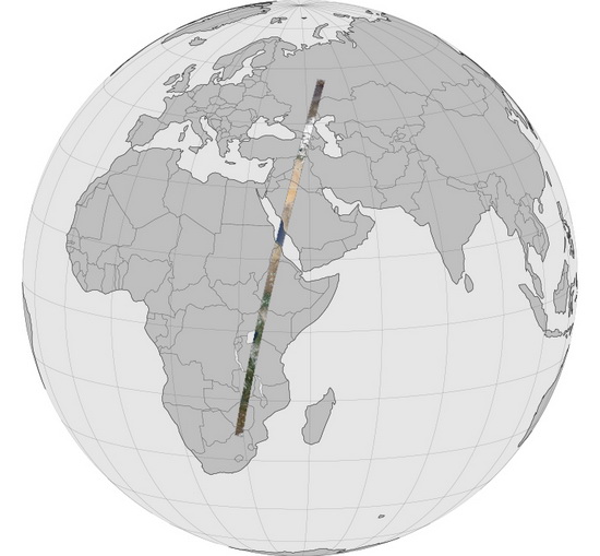
NASA has revealed one of the biggest panoramas ever created, amounting for more than 19 gigapixels and detailing more than 6,000-mile Earth strip.
Technological advancements in the world of optics have allowed photographers to compile gigantic panoramic images of several points of interest.
This trend has been picked up by NASA, which as revealed the Long Swath panorama. It depicts a strip that measures six thousand miles in length and which has about 19 gigapixels.

NASA Long Swath panorama consists of a 6,000-mile-long Earth strip, ranging from Russia to South Africa and measuring 19.06-gigapixel.
NASA’s Landsat Data Continuity Mission satellite captured 6,000-mile 19-gigapixel Long Swath panorama image
A regular photo usually measures several megapixels, but panoramas are reaching sizes of a few hundred megapixels. Well, they have also crossed the gigapixel line on a number of occasion, so NASA has decided to add its contribution with the help of “The Long Swath”, a 19.06-gigapixel panorama of a strip between Russia and South Africa.
NASA has made use of the Landsat Data Continuity Mission to capture several photos of Earth in April 2013. The resulting panorama covers an area of 6,000 x 120 miles and it has been captured from the aforementioned satellite, roaming Earth at an altitude of 438 miles.
LDCM satellite took 56 images in April, while orbiting Earth at speeds of 17,000 mph
Scientists have mentioned that they have combined 56 photos, in order to compile this amazing panorama. All the images have been taken in April and they are showing the climatic variety of our beloved planet, as they are showing Russia’s coldness and South Africa’s hotness.
NASA says that the 56 photos, comprising the Long Swath panorama, have been captured in about 20 minutes. This has been possible because the Landsat Data Continuity Mission satellite is flying over Earth at a speed of about 17,000 miles per hour.
Several viewing options available for the curious eyes
Viewing such an image is not easy and some may even find it overwhelming, but NASA has taken care of all things. The Space Administration has created a 15-minute video to display the panorama, has released the 56 full-resolution photos, has uploaded the 19-gigapixel panorama on GigaPan, and has developed a way which allows users to integrate it into Google Earth.
The 6,000-mile 19-gigapixel Long Swath panorama image mostly depicts landmass, despite the fact that Earth is about 70% covered in water. Either way, it is a joy to behold and it provides a sight that one should not miss.


